
![]()
We are heavily involved in technology and offer the most innovative ways to obtain and model 3-D data while preserving our environment. Our services cover a broad range of industries, such as educational, laboratory, healthcare & medical facilities. We provide 2D & 3D architectural floor plans, civil & structural engineering, forensic scene & heritage preservation, integrated project delivery and Building Information Modeling (BIM), the future of the building technology and construction industries.
Learn More | See Benchmark in Action
|
|
![]()
Learn More | Watch Video


![]()
Benchmark Line & Grade can help you adopt the new standard of construction layout, which integrates project delivery and building information modeling. Find Out More
![]()
What is Clash Detection? Clash detection allows for the effective identification, inspection and reporting of interferences in 3D project model. Read More
![]()
Using Revit software to design the proposed construction, we gain a competitive edge and substantial time relief on the coordination schedule of a project. Read More

![]()
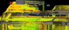
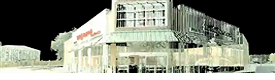
3D scanning technology is an outstanding medium for quickly generating reliable high-resolution 3D recordings for architectural applications. Learn More

![]()
Scanned surveys were used to map Hurricane Katrina's damage to the New Orleans levees. This project would have been difficult with traditional surveying methods. Read More

![]()
HDS and Thermal Imaging provide powerful visualization of the job site, right on your desktop. Users can easily navigate the scene and closely inspect areas of interest. Read More

![]()
3D laser scanning gives you the ability to go back, even years later, to explore detailed images and accurate measurements of the original crime or accident scene. Watch Video


![]()

Here are some case studies that showcase how BIM and integrated project management can save you time and money. Find Out More
 Mount Rushmore to get laser treatment - USA TODAY reports.